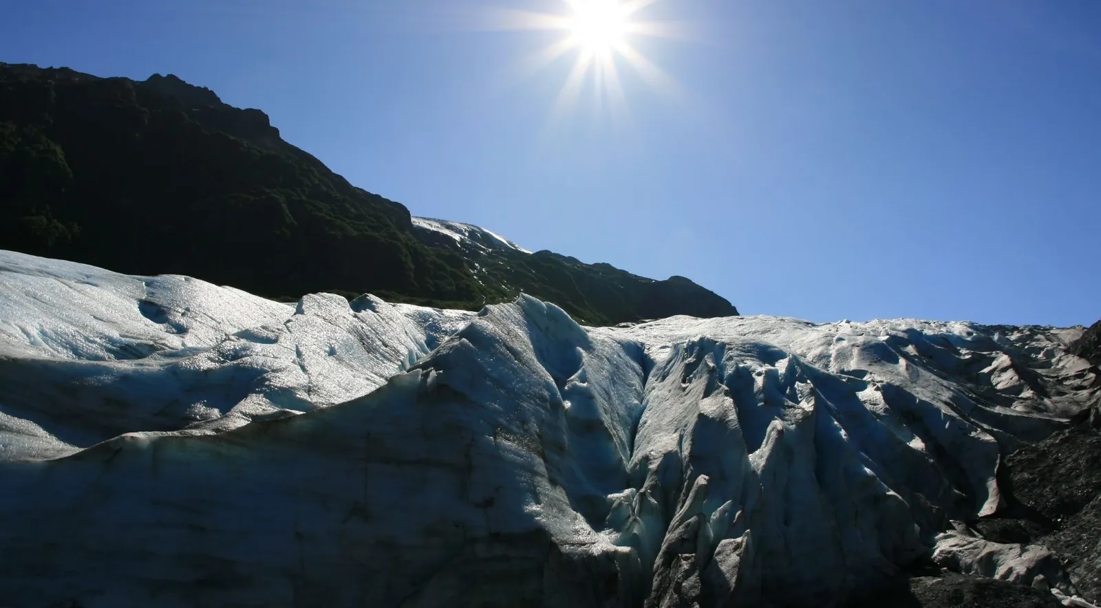
Exit Glacier is the only part of Kenai Fjords National Park you can reach by car, an easy 8.4-mile drive up Exit Glacier Road from the Seward Highway. Know what you are driving out for, though. The short, paved trails no longer touch the ice, the last dated marker on the lower trail shows where the glacier ended in 2010, and the ice has pulled back well beyond it, so many day-trippers who came to “touch a glacier” leave disappointed. The marquee experience is the Harding Icefield Trail, a strenuous climb of roughly 3,100 feet to an overlook of a 700-square-mile sea of ice. There is no entrance fee.
For 2026 the road opened May 14 with heavy lingering snow and notable bear activity, and ranger-led walks run May 23 through September 7. If you want to stand on ice, book a guided ice-hiking or ice-climbing trip or choose a different glacier such as Matanuska or Root. Federal regulation bars you from walking on Exit Glacier within half a mile of its terminus on your own.
What the valley does well is show a glacier in retreat. Roadside markers along the trail record where the ice stood in past years, and it sits off the same Harding Icefield that feeds the tidewater glaciers on the boat tours. The park is already planning for a future when Exit Glacier may no longer be visible from the current trail.
Want the retreat numbers? This page covers the visit itself. The measured terminus record, from the 1815 maximum to the 2016 summer, is on our glacier retreat page, and the wider ice-and-geology picture is in Glaciers & Geology.
Seven things to know before you drive out
- It is the only road access in the park. Exit Glacier sits at the end of Herman Leirer Road, universally called Exit Glacier Road, which leaves the Seward Highway at about Mile 3 and runs 8.4 miles to the Nature Center parking lot. From downtown Seward it is a 15 to 20 minute drive.
- The 2026 season opened May 14. NPS warned of “significant amounts of snow still present” and “evidence of significant bear activity in the vicinity.” The road closes to cars each fall, typically around November, when snow arrives.
- The short trails are a climate-change timeline, not an ice-touching experience. The Glacier View Loop (about 1 mile, wheelchair accessible) and the Glacier Overlook Trail end at the 2010 terminus position, and the ice has since retreated substantially up-valley. Reaching the actual toe means crossing an unmarked, flood-prone outwash plain, and federal regulation prohibits walking on the glacier within ½ mile of the terminus.
- The Harding Icefield Trail is the big hike. NPS’s trail-map PDF states “7.8 miles (12.6 km) roundtrip from [the] Harding Icefield Trail register,” while the main NPS trail webpage says 8.2 miles. Both list 6 to 8 hours and roughly 1,000 feet of gain per mile. NPS’s own materials disagree on exact distance and elevation, so treat either figure as approximate.
- The retreat is exhaustively documented. The NPS report Two Hundred Years of Terminus Retreat at Exit Glacier: 1815 to 2015 (Kurtz & Baker 2016) found 2.5 km of retreat since the 1815 Little Ice Age maximum, with the average rate accelerating to 44.5 m/yr (about 146 ft/yr) in 2011–2015. President Obama visited in September 2015 to spotlight it.
- You can walk on ice only with guides or by air. Exit Glacier Guides and others run ice-hiking and ice-climbing trips that approach the ice by a strenuous hike, in a superintendent-designated area. Helicopter operators land clients on the Harding Icefield.
- Winter turns the road into a groomed multi-use trail. For 2025–26, snowmachine access opened January 13, 2026 and closed April 20, 2026 because of warm temperatures and snowmelt. The Willow Public Use Cabin is bookable in winter.
Other experiences you might enjoy
Around Exit Glacier and Seward you can also book guided Harding Icefield hikes to Marmot Meadows, glacier and wildlife cruises into Aialik Bay, helicopter glacier landings with dog sledding, sea kayaking at Bridal Veil Falls and Tonsina Point, and flightseeing over the Harding Icefield.
The road, the shuttle and the winter closure
Herman Leirer Road (Exit Glacier Road) leaves the Seward Highway (AK-9) at about Mile 3, just before the Resurrection River bridge, and runs 8.4 miles to the Exit Glacier Nature Center parking lot. It is a paved, two-lane road suitable for RVs and large vehicles. The parking lot is small and fills quickly at midday in July and August, so arrive early or late. There are designated car and RV spaces plus roadside overflow parking when the lot is full. From Anchorage it is roughly a 2.5-hour, 120-mile drive south.
The road opens for the season in mid-May (May 14 in 2026) once the snow clears. It closes to cars each fall, typically between late October and November, when the state stops maintaining it, and in winter it becomes a groomed, unplowed multi-use trail.
Shuttle
The Exit Glacier Shuttle and Adventure Sixty North run round-trip van service from Seward hotels, lodges, campgrounds and B&Bs to the Nature Center. Adventure Sixty North lists return departures from Exit Glacier at 10:15 am, 12:15 pm, 2:15 pm, 4:15 pm and 6:15 pm, with pickup 15 to 20 minutes before the scheduled departure, and it sells tickets round-trip only. There is no cell service at the trailhead, so arrange your return before you set out. Adventure Sixty North is also permitted to run shoulder-season and winter van and snow-cat transport when road conditions allow. The fare is budget-tier compared with a guided tour; our getting there guide has the 2026 season dates and price.
Guided trips from Seward and Anchorage
Several operators run guided Exit Glacier nature hikes and ice adventures from Seward. Adventure Sixty North sells a 2.5-hour Exit Glacier Overlook Trail hike with hotel pickup (4.66 from 29 reviews, a smaller review base) and a guided Marmot Meadows hike on the Harding Icefield Trail, lunch included (newly listed, with no reviews yet). From Anchorage, Exit Glacier is a common day-trip glacier, though most guided ice-walking day tours out of Anchorage go to Matanuska Glacier instead, such as this full-day Matanuska Glacier hike from Anchorage (4.82 from 60 reviews).
Bicycles are allowed on the road, and they are a popular winter approach.
The Exit Glacier Nature Center and ranger programs
The Nature Center is open for the summer season, from Memorial Day weekend (the weekend before the last Monday in May) through Labor Day (the first Monday in September), per NPS. Daily hours are commonly cited as around 9 am to 5 pm, but the 2026 clock hours are unconfirmed, so call the park at 907-318-2040 before you plan around them. Inside are exhibits on the glacier, wildlife and climate change, an Alaska Geographic bookstore and rangers to answer questions. Restrooms and drinking-water fill stations are available. There is no food service, so bring your own. The first section of trail from the Nature Center is wheelchair accessible.
Ranger programs (2026). Ranger-led walks run daily from May 23 to September 7, 2026, twice a day at 10:00 am and 2:00 pm. They last about 90 minutes and follow the trail to the Glacier Overlook, and the first portion, to Glacier View, is wheelchair accessible. Pavilion talks of about 20 minutes run once daily from June 6 to August 15, 2026 at 1:30 pm, at the pavilion about 40 yards from the Nature Center. Junior Ranger walks are also offered, and no reservations are required. The park’s 2026 staffing is intact, with a full slate of interpretive programs scheduled, despite 2025 concerns over federal workforce reductions in Alaska (see recent developments).
From an easy paved loop to a strenuous climb
Four main routes, from a short accessible loop to the all-day icefield hike. Three start at the Nature Center; the Resurrection River Trail branches off Exit Glacier Road near Mile 7.
| Trail | Distance | Time | Difficulty |
|---|---|---|---|
| Glacier View Loop Flat, wheelchair-accessible, panoramic glacier view | About 1 mile | 30–60 minutes | Easy |
| Glacier Overlook Trail Extends about 0.6 mile beyond the loop; the closest maintained view of the ice | About 1.8 miles out and back, 330–400 ft of gain | — | Moderate |
| Harding Icefield Trail Climbs beside Exit Glacier to the icefield overlook | 7.8–8.2 miles round trip, about 3,100 ft of climbing | 6–8 hours | Strenuous |
| Resurrection River Trail Mostly level, into the Resurrection River Valley | About 4.5 miles to Martin Creek | — | Mostly level |
Glacier View Loop Trail
About 1 mile of flat, packed gravel and dirt, wheelchair accessible, through cottonwood forest to a panoramic view of Exit Glacier spilling from the Harding Icefield across the outwash plain. Allow roughly 30 to 60 minutes.
Glacier Overlook Trail (Edge of the Glacier)
This route extends about 0.6 mile beyond the loop, climbing partway up exposed bedrock to the closest maintained view of the glacier. The full lower-trail out-and-back runs about 1.8 miles with roughly 330 to 400 feet of gain, and the upper section is moderately strenuous. The trail ends at the glacier’s 2010 position. Because of ongoing retreat, the ice is now well beyond the overlook, and recent visitors report the glacier “is nowhere near that trail anymore.” The paved accessible section reaches the stone pavilion, near the 1917 marker. Past it the trail narrows and steepens.
Reaching the toe means crossing the unmarked outwash plain, about 0.5 mile of braided, flood-prone stream channels. There is no trail, the area is subject to sudden glacial outburst flooding, and NPS closes the canyon from the toe to the outwash plain for safety.
Resurrection River Trail
A less-known, mostly level route into the Resurrection River Valley from about Mile 7 of Exit Glacier Road, running roughly 4.5 miles to Martin Creek. It suits mountain biking, or skiing after snow, and connects toward the longer Resurrection Pass trail system.
The big day hike above the ice
The Harding Icefield Trail is the park’s marquee day hike, leading to an overlook of the 700-square-mile Harding Icefield, one of the largest ice fields entirely within the United States. It is up to about 4,000 feet deep and the source of roughly 38 named glaciers, Exit among them.
NPS materials give conflicting mileage: the official trail-map PDF says 7.8 miles round trip from the trail register, and the main trail webpage says 8.2 miles. Both agree it is strenuous, takes 6 to 8 hours and gains roughly 1,000 feet per mile. Snow lingers on the upper trail into early July and can create avalanche danger, and in winter the trail is a mountaineering route.
Bear country: make noise as you hike and carry bear spray. The trail is exposed, so plan for a full range of weather in a single day.
Waypoints, gear and what the climb is like
The NPS trail map lists these waypoints, measured from the trail register at 426 feet.
| Waypoint | From the register | Elevation |
|---|---|---|
| Bridge | 0.7 mi | 920 ft |
| Marmot Meadows (“lunch rock”), the first big view of Exit Glacier | 1.5 mi | 1,685 ft |
| Top of the Cliffs | 2.3 mi | 2,454 ft |
| Emergency shelter (day use only, not for camping or overnight) | 3.7 mi | 3,456 ft |
| End of trail, the icefield overlook | 3.9 mi | 3,527 ft |
That is a vertical rise of about 3,100 feet. Third-party distance figures vary even more widely than NPS’s, from 7.4 to 9.2 miles, with elevation gain quoted from about 3,000 to about 3,641 feet, so lead with the NPS numbers and expect your own watch to disagree.
Gear: sturdy boots, trekking poles, layers, rain gear, sunglasses and sunscreen, at least 2 liters of water (there is none on the trail), and bear spray.
This is a relentless, quad-burning climb, and it has a real safety history. A 15-year-old died of a medical emergency about 3.7 miles up the trail in July 2023. Many hikers turn around at Marmot Meadows or Top of the Cliffs and still have a great day.
Two centuries of retreat, marked on the trail
Dated signs mark the terminus position over two centuries. The first dated sign on the lower trail is 1917, by the pavilion. Other commonly cited marker years include 1815 (the Little Ice Age maximum), 1899, 1926, 1951, 1961, 1978, 1998, 2005 and 2010.
The Kurtz & Baker 2016 NPS report found Exit Glacier retreated 2.5 km (about 1.55 miles) along its centerline from its 1815 maximum to September 2015. The terminus was roughly stable until about 1889, and after that, in the report’s words:
“During the period of retreat from 1889 to 2015, the average rate was 19.7 m/yr. In the most recent 5-year period from 2011 to 2015, the average rate of retreat was 44.5 m/yr. Over the previous 5-year period from 2006-2010, the rate of retreat was slightly slower, 29.4 m/yr.” (44.5 m/yr is about 146 ft/yr.)
The single worst year on record was 2016. NPS data show the glacier retreated 252 feet over that summer alone, the most of any summer on record, and 293 feet across the full year. NPS also recorded 187 feet of retreat in 2013–14. The glacier now retreats in winter as well as summer, a pattern consistent since 2006.
President Obama visited Exit Glacier on September 1, 2015, as part of a trip on which he became the first sitting president to visit the American Arctic. Standing near the foot of the glacier, he said, per the official White House transcript: “This glacier has lost about a mile and a half over the last couple hundred years… this is as good of a signpost of what we’re dealing with when it comes to climate change as just about anything.” The lower trail once ended in a loop that reached the ice. NPS has repeatedly rerouted and extended it as the glacier pulled back, and it now stops at the 2010 marker.
Honest expectations for the short trails
From the Glacier Overlook you get a genuine, close-ish view of fluted blue-and-white ice, crevasses, scoured bedrock, rushing meltwater and a recovering forest, and on a still day you can hear the ice crackle and pop. You cannot touch the ice from the short trails. From May 1 to October 31 you also cannot legally walk on the glacier within ½ mile of the terminus (36 CFR §13.1312).
The trade-off is this: road access and interpretive markers make Exit Glacier the best place in Southcentral Alaska to understand a glacier and see climate change made visible. It delivers a smaller, more distant ice experience than a Kenai Fjords boat cruise, where you watch tidewater glaciers such as Aialik or Holgate calve into the sea from close range. If your dream is dramatic calving or standing on ice, set your expectations to match, and see our boat tours guide for the cruises that reach those glaciers.
Ice, floods, bears and weather at Exit Glacier
Ice-fall and rockfall
- Huge chunks of ice fall from the terminus without warning, and loose rock and talus are common near the toe.
- That is why approaching the ice is prohibited and why designated trails avoid the hazard zone.
Glacial outburst floods
- The Exit Glacier canyon and outwash plain are subject to sudden surges of water, ice, rock and debris regardless of weather.
- Seek high ground if water rises.
Bears and moose
- Bear activity is a recurring theme. The 2026 opening release again flagged “significant bear activity.”
- On the evening of September 24, 2025, two hikers who were carrying no bear spray were injured by a bear about a quarter-mile from the trailhead. Both self-transported and were reported in stable condition, and NPS closed the trails and gate until 8:00 am on September 27.
- Carry bear spray, make noise and hike in groups of three or more. Pets are prohibited on trails.
- Moose frequent the valley bottom and are occasionally on trails.
Harding Icefield exposure
- Weather changes fast: wind, storms, hypothermia risk, intense sun and snow glare, and snowfields with avalanche danger into July.
- The emergency shelter near the trail’s end is for weather emergencies only.
Cell service and rescue
- Cell service is essentially nonexistent at the trailhead and on the trail, and local search and rescue is limited.
- Plan within your abilities and arrange your shuttle pickup in advance. Our safety guide covers the wider park.
Getting on the ice, or above it
- Ice hiking. Operators including Exit Glacier Guides (in business about 15 years, with what it calls a perfect safety record) and Kenai Backcountry Adventures approach the ice by a strenuous 1.3 to 2 hour, 1,300 to 1,400 foot uphill hike on the national-park trail, then a rocky descent to the ice. There you gear up with crampons, harness and helmet and explore blue ice, crevasses and meltwater features. Total hiking distance is about 4 miles, it suits fit, adventurous beginners, and it is a full day of roughly 8 to 9 hours. Gear is provided. Kenai Backcountry Adventures sells an 8-hour Exit Glacier ice hiking trip from Seward with round-trip transport (5.0 from 7 reviews, a very small review base).
- Ice climbing. Full-day trips add instruction in crampon technique, ice-tool use and rappelling into crevasses. They start earlier, around 8 am, and require good fitness. Two-day options add remote-glacier moulin climbing by helicopter or camping at the glacier’s edge.
- Guided Harding Icefield Trail hikes. For the big hike with a guide, there is a guided Marmot Meadows hike with lunch (newly listed, with no reviews yet), a shorter outing that stops at Marmot Meadows and does not reach the icefield overlook. Adventure Sixty North also rents poles and bear spray and guides to Marmot Meadows and beyond.
- Helicopter landings. Multiple Seward operators, including Seward Helicopter Tours and Seward Air, fly onto the Harding Icefield or spillover glaciers for a walkabout. Some combine glacier landings with dog sledding on Godwin Glacier, and there is a helicopter glacier landing and dog sledding trip (5.0 from 22 reviews). This is the priciest tier and it depends on weather.
- How guided differs from doing it yourself. On your own you can hike the trails and view the ice, but you cannot legally walk on Exit Glacier near the terminus. Guided trips operate in a superintendent-designated area with technical gear and instruction, which is the only lawful and safe way onto Exit Glacier’s ice.
Exit Glacier from November to mid-May
From roughly November to mid-May the road is closed to cars and becomes a groomed multi-use route for cross-country and skate skiing, snowshoeing, fat-biking, dog mushing and, when conditions allow, snowmachining. For 2025–26, NPS opened the Exit Glacier developed area to snowmachine use on January 13, 2026 and closed it April 20, 2026 because of warm temperatures and snowmelt, the second straight low-snow winter to force adjustments.
From the winter gate, about 1.5 miles off the Seward Highway at Box Canyon, it is roughly 7 miles to the Exit Glacier area, plus about 1 mile to the overlook. A day-use warming hut with a wood stove and pit toilets is available at Exit Glacier, with no potable water.
The Willow Public Use Cabin has propane heat, a stove and lights, sleeps four, and has no running water and a pit toilet. It costs $50 a night with a three-night maximum and is bookable from mid-November to mid-April. Reserve by phone at 907-318-2040. Reservations open the second Wednesday of October.
Avalanche terrain exists on the Harding Icefield Trail, so check the daily forecast. Winter visiting suits solitude-seekers comfortable with self-reliant, non-motorized travel (or permitted snowmachining), but it is a backcountry outing, not a casual stop. Our best time to visit guide covers what else is open in winter.
Exit Glacier Campground
Exit Glacier Campground is the park’s only drive-up campground: 12 walk-in, tent-only sites, free, first-come first-served, with no reservations and a 14-day limit. It frequently fills by early evening in July and August. There are no RVs, trailers or overnight vehicle parking, so cars park at the campground entrance and you walk in. Two sites, #1 and #12, are accessible, with crushed-rock and asphalt paths.
A central food-storage locker and a covered cooking and dining shelter are provided. Cooking or storing food at individual sites is prohibited, since this is bear country and the boxes show claw marks. Drinking water comes from a hand pump, pit toilets are open year-round, and pets are not allowed. Bear-resistant food canisters, required for backcountry camping, are available at the Nature Center. For the full lodging picture, see where to stay near Kenai Fjords.
How much time do you have?
| Your time | What to do | Notes |
|---|---|---|
| Quick 90-minute stop | Nature Center exhibits plus the Glacier View Loop | Enough to see the glacier from a distance and read the retreat markers |
| Half day (3–4 hours) | Add the Glacier Overlook Trail and a ranger-led walk at 10 am or 2 pm | Best value for most visitors |
| Full day | The Harding Icefield Trail, 6–8+ hours | Commit to it, or plan a turnaround at Marmot Meadows or Top of the Cliffs |
| With a boat cruise | A half-day fjords cruise plus the short Exit Glacier trails | Very doable in one day from Seward. The Harding Icefield Trail plus a full-day cruise is not realistic in one day, so split them across two |
Already cruised? The short trails and markers are still worth it if you want the land perspective and the climate story, and the Harding Icefield hike is a distinct, world-class experience whatever cruise you have taken. Already done Exit Glacier? Take the boat anyway: a full glacier cruise (4.85 from 948 reviews) or a half-day Resurrection Bay cruise (4.70 from 99 reviews) delivers close tidewater calving that the land side cannot.
Other glaciers you can reach by road or trail
Exit Glacier sits near the top for road access and interpretation, and near the bottom for walking on ice by yourself.
| Glacier | Where | What you get |
|---|---|---|
| Matanuska Glacier | Glenn Highway, about 2.5 hours from Anchorage | The largest road-accessible glacier in the U.S. It is on private land, so you can drive to the edge and, on a guided trek, walk on the ice. Best for casual ice-walking near Anchorage |
| Root Glacier | Wrangell–St. Elias, from Kennicott | Reached by a moderate hike. An excellent, relatively easy walk on ice with a guide (or experienced DIY). Remote but superb |
| Worthington Glacier | Richardson Highway, about 28 miles from Valdez | Park and walk a short trail near the face |
| Byron Glacier | Portage Valley | An easy walk of about 1.4 miles round trip toward the ice and avalanche-debris “ice caves.” The caves are dangerous and deaths have occurred, so do not enter |
| Portage Glacier | Portage Lake | No longer visible from the road. Best seen by tour boat on Portage Lake (a full-day Anchorage tour includes the 1-hour boat trip), or on foot across the frozen lake in deep winter |
| Mendenhall Glacier | Juneau | Alaska’s famous drive-in glacier, with a visitor center. View it from afar, hike the West Glacier Trail toward the ice, or paddle to the face on a guided canoe tour (summer, permit limited) |
Where Exit Glacier ranks. For road accessibility plus an interpretive, ranger-supported experience, it is near the top. For actually walking on ice on your own, it ranks poorly: that is prohibited near the terminus, and the ice has retreated far from the trails. If ice-walking is the goal, choose Matanuska or Root, or book a guided or helicopter trip at Exit Glacier.
What has changed lately
- 2026 opening. The road opened May 14, 2026, with heavy lingering snow and flagged bear activity.
- Bear incident. On September 24, 2025, two hikers were injured by a bear near the Exit Glacier trailhead, prompting a closure that lasted until September 27 and reinforcing the 2026 bear warnings.
- Snowmachine season. It opened January 13, 2026 and closed April 20, 2026 for snowmelt, a second consecutive low-snow winter affecting access.
- Staffing. In March 2025 there was public concern, and a rally in Seward, over federal workforce reductions affecting Alaska public lands. Thirty-two Forest Service layoffs were confirmed at neighboring Chugach National Forest, and Kenai Fjords impacts were reported anecdotally. The park’s 2026 fact sheet and program schedule indicate seasonal ranger programs are fully operating.
- Trail status. No new 2026 reroutes or budget-driven trail closures have been reported. The standing safety closure of the Exit Glacier canyon and toe, because of outburst-flood risk, remains, and ongoing retreat continues to move the ice farther from the lower trails.
Six things we’d tell a friend
Decide what you want before you drive out.
To see and understand a glacier with minimal effort, do the Nature Center, the Glacier View Loop and a ranger walk, and accept that you will not touch ice. To stand on ice, book a guided ice hike or climb at Exit Glacier or a helicopter landing, or go to Matanuska or Root. For dramatic calving, take a fjords boat cruise.
Attempt the Harding Icefield Trail only if you are fit and prepared.
Expect a 3,000-plus foot climb over 6 to 8+ hours. Check current conditions and the avalanche forecast at the Nature Center, start early, carry bear spray, poles, layers, rain gear and 2+ liters of water, and pre-arrange your shuttle. Use Marmot Meadows or Top of the Cliffs as honest turnaround points.
Beat the parking crunch.
Arrive before about 9:30 am or after about 4 pm in July and August, or take the shuttle.
Camp only if you can arrive by early afternoon.
Exit Glacier Campground works if you are comfortable with tent-only, bear-aware camping and no RV.
Go in winter only if you are self-reliant.
It suits skiers, snowshoers, fat-bikers and permitted snowmachiners. Book the Willow Cabin in advance and check road and snow conditions.
Know what would change this advice.
If NPS opens a lower-trail extension closer to the current terminus, or a low-snow year like 2025–26 forces an earlier road opening or trail changes, re-check the NPS conditions page. If bear activity closes the trails, as it did in September 2025, have a backup plan such as a cruise or another glacier.
Details to confirm for your dates
Much of this page is seasonal or comes from operators. Check these against nps.gov/kefj before you plan around them.
- Harding Icefield Trail distance and elevation gain. NPS itself is inconsistent: the trail-map PDF says 7.8 miles round trip and the main trail webpage says 8.2. Third-party figures range from 7.4 to 9.2 miles and from about 3,000 to about 3,641 feet of gain.
- Road opening and closing. The May 14, 2026 opening is confirmed by NPS. The fall closing date varies year to year with snow.
- Nature Center hours. The season (Memorial Day weekend to Labor Day) is confirmed by NPS, but the exact clock hours, commonly cited as about 9 am to 5 pm, are not confirmed for 2026. Call 907-318-2040.
- Ranger programs. Walks run May 23 to September 7, 2026 at 10 am and 2 pm, and pavilion talks run June 6 to August 15 at 1:30 pm, per NPS. Both are subject to staffing.
- Shuttle schedule and operators. The Adventure Sixty North return times above come from a recent season, so confirm the 2026 schedule and that a dedicated Exit Glacier Shuttle operates.
- Snowmachine dates. January 13 and April 20, 2026 are confirmed by NPS releases and vary each year.
- How far the ice is from the overlook. No official figure was found for the distance from the 2010 overlook to the current terminus. It is described only as well beyond the trail.
- Retreat figures. The Kurtz & Baker (2016) numbers, including 19.7 m/yr for 1889–2015 and 44.5 m/yr for 2011–2015, are solid through 2015. The 2016 record (252 feet in the summer, 293 feet across the year) and the 187-foot 2013–14 figure come from NPS data reported secondhand, and no official 2020–2026 monitoring update was located.
- Marker years. 1917, 2005 and 2010 are confirmed. The rest of the list comes from secondary sources, so verify on site.
- Guided-trip specifics and the Willow Cabin fee. Hike distances, elevation and inclusions come from operator sites, and the $50 a night Willow Cabin fee and reservation window come from NPS. Confirm 2026 offerings and current fees. We quote no guided-trip prices here.
Exit Glacier questions
It is strenuous. NPS materials give 7.8 miles round trip (trail-map PDF, from the trail register) and 8.2 miles (main trail webpage), with about 3,100 feet of climbing, roughly 1,000 feet of gain per mile, and 6 to 8 hours for most hikers. It climbs beside Exit Glacier to an overlook of the Harding Icefield. Snow can linger on the upper trail into early July and create avalanche danger, so check conditions at the Nature Center. Many hikers turn around at Marmot Meadows or Top of the Cliffs and still have a great day.
You can walk to viewpoints, but not to the ice. The Glacier View Loop (about 1 mile, wheelchair accessible) and the Glacier Overlook Trail end at the glacier's 2010 position, and the ice has since retreated well beyond them. Reaching the toe means crossing a flood-prone outwash plain with no trail, and NPS closes the canyon there. From May 1 to October 31 it is also illegal to walk on the glacier within half a mile of its terminus on your own.
Only on a guided trip or by air. Exit Glacier Guides and other operators run ice-hiking and ice-climbing trips in a superintendent-designated area, with crampons, harness and helmet provided, and helicopter operators land clients on the Harding Icefield. If you want easy ice-walking without a strenuous approach, Matanuska Glacier near Anchorage and Root Glacier near Kennicott are the usual alternatives.
A car is simplest, using Herman Leirer Road (Exit Glacier Road) off Mile 3 of the Seward Highway, 8.4 miles to the Nature Center. Round-trip van service also runs from Seward hotels, lodges and campgrounds, with return departures from Exit Glacier listed at 10:15 am, 12:15 pm, 2:15 pm, 4:15 pm and 6:15 pm in a recent season. There is no cell service at the trailhead, so arrange your return before you set out. The road is closed to cars from about late October or November until mid-May, and it opened May 14 in 2026.
Yes. The Harding Icefield Trail runs through active black-bear country, and black bears are spotted almost daily along it in summer. The 2026 opening release flagged significant bear activity, and two hikers without bear spray were injured near the trailhead in September 2025, and NPS closed the trails and gate until September 27. Make noise, carry bear spray and hike in groups of three or more. Pets are prohibited on trails.
It is the only part of Kenai Fjords National Park reachable by road, with no entrance fee, and it is the best place in Southcentral Alaska to understand a glacier and see retreat made visible. It is not an ice-touching stop, and it delivers a smaller, more distant ice experience than a boat cruise to a calving tidewater glacier. The strenuous Harding Icefield Trail is a distinct, world-class hike in its own right.
Yes, with a half-day fjords cruise and the short Exit Glacier trails, which is very doable from Seward. The Harding Icefield Trail plus a full-day cruise is not realistic in one day, so split them across two. Visiting Exit Glacier does not replace a cruise, because the boat delivers close tidewater calving that the land side cannot.
The road is closed to cars from roughly November to mid-May and becomes a groomed multi-use route for skiing, snowshoeing, fat-biking, dog mushing and, when conditions allow, snowmachining. In 2025-26 the snowmachine season ran January 13 to April 20, 2026. From the winter gate at Box Canyon it is about 7 miles to the Exit Glacier area. The Willow Public Use Cabin ($50 a night, sleeps four) is bookable from mid-November to mid-April by phone, and avalanche terrain exists on the Harding Icefield Trail.
An NPS report (Kurtz and Baker, 2016) found 2.5 km of retreat along the centerline from the 1815 maximum to September 2015. The average rate was 19.7 m/yr from 1889 to 2015 and accelerated to 44.5 m/yr in 2011-2015. NPS data show the glacier retreated 252 feet over the summer of 2016 alone, the most of any summer on record, and 293 feet across that full year.
Yes. Exit Glacier Campground has 12 free, first-come, walk-in, tent-only sites with a 14-day limit and no reservations. It has no RV sites or overnight parking, and it frequently fills by early evening in July and August. Food must stay in the central storage locker and cooking shelter because of bears, and pets are not allowed in campsites.
Related guides
Ready to plan your Exit Glacier day?
Check the road and shuttle timing for your dates, pack for cold, wet, sun and bears, and leave a flexible day for weather.